Geography of Sweden
| Sweden | |
 |
|
| Continent | Europe |
| Subregion | Scandinavia |
| Geographic coordinates | |
| Area - Total - Water |
Ranked 55th 449,964 km² 39,03- km² (8.69%) |
| Coastline | 3,218 km (2,000 mi) |
| Land boundaries | 2,333 km (1,550 mi) |
| Countries bordered | Norway 1,169 km Finland 614 km |
| Highest point | Kebnekaise, 2,111 m / 6,926 ft |
| Lowest point | Kristianstad, -2.41 m |
| Longest river | Klarälven-Göta älv, 720 km (447.4 mi) |
| Largest inland body of water | Vänern 5,648 km² (3,510 sq mi) |
| Land Use - Arable land - Permanent crops - Other |
5.93 % 0.01 % 94.06 % (2005 est.) |
| Irrigated Land | 1,150 km² |
| Climate: | Temperate to subarctic |
| Terrain: | flat lowlands, mountains |
| Natural resources | iron ore, copper, lead, zinc, gold, silver, tungsten, uranium, arsenic, feldspar, timber, hydropower, windpower |
| Natural hazards | ice flow, hurricanes |
| Environmental issues | acid rains, Eutrophication |
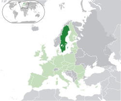
Sweden is a country in Northern Europe on the Scandinavian Peninsula. Its borders are Norway to the west; Finland to the northeast; and the Baltic Sea and Gulf of Bothnia to the east and south.
Sweden has a long coastline on the eastern side and the Scandinavian mountain chain (Skanderna) on the western border, a range that separates Sweden from Norway. It has maritime borders with Denmark, Germany, Poland, Russia, Lithuania, Latvia, and Estonia, and it is also linked to Denmark (southwest) by the Öresund Bridge. At 449,964 km2 (173,732 sq mi), Sweden is the 55th largest country in the world. It is the 5th largest in Europe, and the largest in Northern Europe.
Contents |
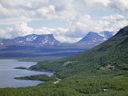
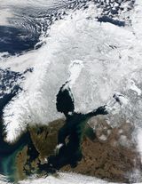
Terrain
.png)
Much of Sweden is heavily forested, with 78% of the country being forest and woodland, while farmland constitutes only 1% of land use. Southern Sweden is predominantly agricultural, with increasing forest coverage northward. Mountains and hills are dominant in the west. About 15% of Sweden lies north of the Arctic Circle.
The lowest elevation in Sweden is in the bay of Lake Hammarsjön, near Kristianstad at
-2.41 m (−7.91 ft) below sea level. The highest point is Kebnekaise at 2,111 m (6,926 ft) above sea level.
The highest population density is in the Öresund region in southern Sweden and in the valley of lake Mälaren near to Stockholm. Gotland and Öland are Sweden's largest islands; Vänern and Vättern are its largest lakes. Vänern is the third largest in Europe, after Lake Ladoga and Lake Onega in Russia.
Sweden consists of 39,030 km² of water area, constituting around 95,700 lakes.[1] The lakes are sometimes used for water power plants, especially the large northern rivers and lakes. The two largest islands are Gotland and Öland in the southeast. They each have their own culture, most notably Gotland with the old, largely intact and heritage-filled city Visby.
Political divisions
Provinces
Sweden has 25 provinces or landskap (landscapes), based on culture, geography and history: Bohuslän, Blekinge, Dalarna, Dalsland, Gotland, Gästrikland, Halland, Hälsingland, Härjedalen, Jämtland, Lapland, Medelpad, Norrbotten, Närke, Skåne, Småland, Södermanland, Uppland, Värmland, Västmanland, Västerbotten, Västergötland, Ångermanland, Öland and Östergötland.
While these provinces serve no political or administrative purpose, they play an important role for people's self-identification. The provinces are usually grouped together in three large lands (landsdelar): the northern Norrland, the central Svealand and southern Götaland. The sparsely populated Norrland encompasses almost 60% of the country.
Counties
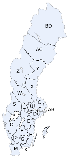
Administratively Sweden is divided into 21 counties or län. In each county there is a County Administrative Board or länsstyrelse which is appointed by the government.
In each county there is also a separate County Council or landsting, which is the municipal representation appointed by the county electorate.
- K = Blekinge County
- W = Dalarna County
- I = Gotland County
- X = Gävleborg County
- N = Halland County
- Z = Jämtland County
- F = Jönköping County
- H = Kalmar County
- G = Kronoberg County
- BD = Norrbotten County
- M = Skåne County
- AB = Stockholm County
- D = Södermanland County
- C = Uppsala County
- S = Värmland County
- AC = Västerbotten County
- Y = Västernorrland County
- U = Västmanland County
- O = Västra Götaland County
- T = Örebro County
- E = Östergötland County
The letters shown were on the vehicle registration plates until 1973 .
Municipalities
Each county is further divided into municipalities or kommuner, ranging from only one (in Gotland County) to forty-nine (in Västra Götaland County). The total number of municipalities is 290.
The northern municipalities are often large in size, but have small populations – the largest municipality is Kiruna with an area as large as the three southern provinces in Sweden (Scania, Blekinge and Halland) combined, but it only has a population of 25,000, and its density is about 1 / km².
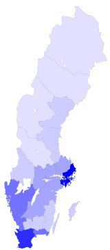
people/km²
0-9.9 10-24.9 25-49.9 50-99.9 100-199.9 200+
Population
Sweden has a population of about 9 million. The north is less populated than the southern and central parts, mostly because of its colder climate.
Cities
Cities and towns in Sweden are not political or administrative entities but localities or urban areas, independent of the municipal subdivision. The largest city, in terms of population, is the capital Stockholm, in the east, the dominant city for culture and media, with a population of 1,250,000. The second largest city is Gothenburg, with 510,500, in the west. The third largest is Malmö in the south, with 258,000. The largest city in the north is Umeå with 76,000 inhabitants.
Natural resources
Sweden's natural resources include copper, hydropower, iron ore, lead, silver, timber, uranium, and zinc.
Environment
Acid rain has become an issue because it is damaging soils and lakes and polluting the North Sea and the Baltic Sea. The HBV hydrology transport model has been used to analyze nutrient discharge to the Baltic from tributary watersheds.
See also
- Geographical center of Sweden
- List of cities in Sweden
- List of islands of Sweden
- List of lakes in Sweden
- List of municipalities of Sweden
- List of national parks of Sweden
- List of rivers in Sweden
- Climate of Sweden
References
Notes
Sources
- CIA World Factbook 2001
- CIA World Factbook 2006
|
||||||||||||||